Paul has a couple of Jeeps to choose from
when he goes for a Saturday drive, including a new Grand Cherokee, so I was
over the moon when he rocked up in his Cherokee Chief, a rare limited model
from 1980. Vic and I had a ’79 model and
it’s always been our favourite. Paul has
spent a lot of time (and $$$, I’m sure!) making this jeep extra special and it’s
common knowledge that it’ll go to the grave with him.
Our first stop was one of the many coffee
shops in town and despite the windy conditions, we sat outside, while all the
regulars sat inside. We should have
remembered the old saying… When in Rome, etc!
The only thing that wasn’t cold was the coffee! We checked out the Terrace Shops, which were
originally built in 1886 as housing for the local quarry workers and are now
classified as historic buildings with the National Trust.
 |
| Kiama Blowhole |
The first recorded reference to the Kiama
Blowhole was in 1797, and on our first ever visit, it was working beautifully
still, thanks to the seas running from the south-east, which create the most impressive
displays. As you leave Blowhole Point you
pass the harbour and fresh seafood shop, so fresh seafood seemed the obvious choice for lunch. A short distance down the coast is the Little Blowhole,
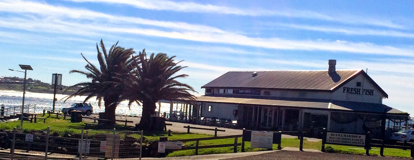 |
| Kiama Harbour and Seafoods |
so we set off to check it out after a great fish and chip meal. This one works best with seas from the
north-east, so wasn’t at it’s best, but still great to watch. Paul had a 2½ hour drive home so headed off
late in the afternoon leaving Vic and I to hibernate inside the van.
Overnight, the wind got wilder and was gale
force by the morning. It was the day of
“Wings over the Illawarra”, probably the biggest celebration in Australia of
all things aeronautical, and as much as I’d have liked to go, I’m glad we
didn’t… most of the aircraft were unable to fly due to the dangerous
conditions.
 |
| Saddleback Mountain views |
Vic and I headed over to the blowhole again
and it was far more active than the day before.
Even though the wind was making things uncomfortable (and bloody cold!)
it was a beautiful clear day so we headed down the coast road and took the 1½
klm drive up Saddleback Mountain Road to the lookout which sits 662 metres
above the coast. From here we had an
amazing view out over Kiama far below and north over beautiful rolling farmland
to Wollongong, nestled between the Illawarra Escarpment and the coast.
As we drove back down Saddleback Mountain
we stopped to take in the view south along the coast to Berry, and then to photograph
one of the 400 dry stone walls, which have been identified in the Kiama
area. These walls were constructed over
100 years
 |
| Some of the many dry stone walls |
ago, most of them by Thomas Newing who built stone walls for 60
years, and these divide properties, paddocks and roadways. We then drove south along the coast, checking
out some of the small villages and beaches as we went, before arriving in Berry,
which was absolutely pumping with people and traffic. This is clearly where a
lot of Sydney-siders like to spend their Sundays and a popular destination for
car clubs on Sunday cruises.
 |
| Berry Post Office |
The wind had eased by the following morning
and left a glorious day, but still very cold.
Before Vic and I left on this journey in 2012, we had both made a list
of “must do’s”, things each of us wanted to see, do or achieve while on this
trip, and on this particular day, I was going to tick one off that list. We headed north and at Shellharbour, turned
off the M1 and followed the tourist drive, which took us through Port Kembla
and onto Wollongong.
 |
| WIN Stadium |
 We checked out ‘Win
Stadium’, home of the St. George - Illawarra Dragons, (my mate Phil calls them
the Mighty Dragons!) and then had morning tea at Flagstaff Point. The view up and down the coast from here, is
beautiful, and it gives you a good perspective of ‘The Gong’. It’s an interesting walk around this point
with a lighthouse, 19th century cannons and a gun emplacement to
explore.
We checked out ‘Win
Stadium’, home of the St. George - Illawarra Dragons, (my mate Phil calls them
the Mighty Dragons!) and then had morning tea at Flagstaff Point. The view up and down the coast from here, is
beautiful, and it gives you a good perspective of ‘The Gong’. It’s an interesting walk around this point
with a lighthouse, 19th century cannons and a gun emplacement to
explore.
 |
| Flagstaff Point Lighthouse in Wollongong |
Our drive was going to take us to the Sea Cliff
Bridge, a magnificent piece of Australian architecture, which I’ve wanted to
visit for some time since seeing it regularly on TV commercials, particularly
car ads. While having a cuppa at
Flagstaff Point, I was talking to a local who informed us that access to the
bridge from the south along the coast road wasn’t possible because the road was
closed for a week due to roadworks. Vic
and her Ipad worked out a way we could bypass the spot and get to the bridge
from the north, but this meant getting back onto the M1 and heading for Sydney
before turning back toward the coast.
To get to the M1 we needed to make our way
up the Bulli Pass, a piece of road that runs up the eastern face of the
Illawarra Escarpment and rises over a kilometer in a very short distance. This
is not a road you want to take a caravan on… it’s steep and long. Heading up or down, this would be brutal on
any tow vehicle. At the top of the pass
you rejoin the M1, and just near here is the Illawarra Tourist Info Centre. The centre is perched on the edge of the
range and has a deck that is 1,128 metres above sea level and affords an
absolutely spectacular view of the coast.
This deck hangs precariously out into the void and is not for the faint
hearted.
 |
| Looking south across Wollongong from the Illawarra Tourist Info Centre |
New South Wales roads are generally pretty
good but don’t always make sense. We
were travelling north on the M1 towards Sydney and were able to turn off to
visit the tourist info centre, however, you can’t rejoin the M1 in that
direction, so after some more searching by Vic and a 20klm detour, we were back
on track and could actually see the Sydney city buildings in the distance. We took the turn off to
 |
| Stanwell Park |
Stanwell Park, a
little seaside village, and headed to Bald Point. There is a really nice park and picnic area
here (with a resident mobile café!) and a fantastic view down the coast, which
gives you a real appreciation of the fantastic Sea Cliff Bridge. I was ecstatic to be finally standing here
and taking this all in, even though it had taken us 4½ hours to get here, about
45klms north of Kiama.
After 4 nights in Kiama we got back on the
Princes Highway and continued south driving through Nowra and taking the turn
off, soon after, that lead us into the Jervis Bay area. Our good friends, Phil and Sue, recommended
we stay at Huskisson after their recent visit.
Vic and I booked into the White Sands Caravan Park (also on their
recommendation!) and got a great site with a view out over Jervis Bay.
 |
| Huskisson's White Sands Caravan Park |
This is a really nice park with spotless
amenities and grounds. It’s a 10 minute
walk into town with a great pub, good selection of shops, cool cafes and an
awesome bakery.
 |
| Coffee time |
While Vic and I were
looking around we booked a cruise on the bay, for the next day, which promised
dolphin spotting, morning tea, an informative commentary and a good time to
boot.
 |
| Windblown Jervis Bay |
We were up bright and early the next
morning and just about ready to leave when we got a phone call to inform us
that due to the high winds and rough conditions on the bay, there would be no
cruise
today. We decided to take a drive
and visited Hyam Beach, said to have some of the whitest sand in Australia (I
don’t reckon it’s anywhere near as white as the Whitsundays!), then over to
George’s Basin, a large salt water lake about 10 klms inland from the bay.
 |
| Hyam Beach |
 |
| Pristine waters of Jervis Bay looking across to Cape Perpindicular |
The water of Jervis Bay is probably the
clearest you’ll ever see and the whole area is naturally pristine. The water
here is so clear because there are no large rivers or creeks draining into it
and very little urban development. The population of the villages around Jervis
Bay is only 6,500 and no sewerage enters the bay, it’s all been recycled since
2002 and used to water golf courses etc in the area. Also, the rich biodiversity, good mangrove
system, the native trees, shrubs and grasses along the foreshore and the large
areas of seagrasses in the bay help keep the water healthy.

So with that in mind, it’s hard to believe
that all of this could have been lost in the 80’s when the approval was given
to build a nuclear power station here.
Work actually commenced before public opposition and protests forced the
government to cancel the project. If you
check Google Earth you can see areas of the seagrass missing where the sea
floor was dynamited in preparation for the huge wharf that was to be built to
service the power station.
 |
| Waiting for our Dolphin cruise to commence |
 |
| St George's Basin |
The following morning was still quite windy
but the cruise was going ahead anyway.
Vic and I were there on time and 15 minutes after the proposed departure
time we were still sitting at the dock when those of us on board were told that
we were waiting for two groups to arrive.
Shortly after, a group of Asian businessmen boarded and then a large
group of seniors. By the time we headed
out into the bay, the seas were extremely rough and the wind was
strengthening. Luckily, most of us had
our morning tea while sitting at the dock, because it was near impossible to
make your way around the boat in these conditions. We headed out to the eastern side of the bay,
looked for dolphins for 10 minutes, saw none, came back across the bay with no
commentary at all, then berthed 1½ hours later.
Not real happy!
 |
| Jervis Bay - Huskisson |
Vic and I walked over to the bakery and had
a great lunch before having a lazy afternoon around the van and preparing to
continue south the next day.
Until next week… Happy travels!


No comments:
Post a Comment