|
| Eden spot #1 |
We seem to have made a habit of checking
out of van parks at about 10.30 (10am being the normal checkout) but none of the parks
we’ve visited have been real busy so no one has complained yet. We left Tathra and made our way further south
heading for Eden, our last stopover before entering Victoria. Late last year Vic had won an auction on line,
at www.travelauctions.com.au for 10 days at the Big4 caravan park at Eden after
being referred to the site by a caravanning couple that we had met while in
Hervey Bay. These are very popular in
the southern states and regularly advertise their offers on TV. The top 50 bidders win and Vic got us a stay for
10 nights on a powered van site (at a really good price) and so we made
straight for Eden, knowing we would have plenty of time to explore the
area. It is only 27klms from Tathra to
Merimbula, and then a further 22klms to Eden, so 1½ hours after checking out of
Tathra, we checked into Eden in time to put the kettle on.
 |
| Twofold Bay |
Our first stop after setting camp was the
Tourist Info Centre, where we got some great advice and suggestions on how to
spend our time here. That first day in
town, we went to the Rotary Park Lookout, which has a fantastic view over beautiful
Twofold Bay, the third deepest natural harbour in the Southern Hemisphere, and
inland to Mt Imlay with the rugged hills that lead into the Great Dividing
Range and the three national parks that surround Eden.
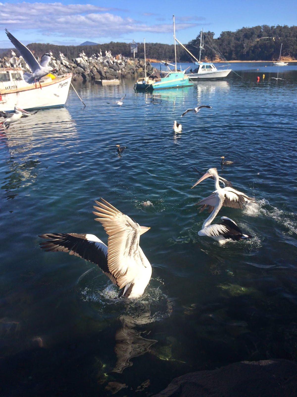
 We then stopped off at Snug Cove, where
explorers, Bass and Flinders came ashore in 1798, and where one of the largest
fishing fleets in New South Wales is based.
This is a working port and visitors are welcome to wander around and
watch the fisherman unloading their catch and prepare it for the Sydney and
Melbourne markets. Overseas cruise
liners sometimes call into Eden (anchoring in Twofold Bay) and travelling
yachtsmen regularly drop in here, especially during the Sydney to Hobart Yacht
Race.
We then stopped off at Snug Cove, where
explorers, Bass and Flinders came ashore in 1798, and where one of the largest
fishing fleets in New South Wales is based.
This is a working port and visitors are welcome to wander around and
watch the fisherman unloading their catch and prepare it for the Sydney and
Melbourne markets. Overseas cruise
liners sometimes call into Eden (anchoring in Twofold Bay) and travelling
yachtsmen regularly drop in here, especially during the Sydney to Hobart Yacht
Race.
 |
| Eden spot #2 |
It’s hard to believe that in this part of
the country, densely populated as it is, that TV reception is so pathetic. We have a new state of the art boosted
digital TV aerial on this van and yet we’ve had more problems, in New South
Wales, getting reception than we ever had with the old cheap as chips ‘Happy
Wanderer’ we used in the last van, even in outback Queensland and Northern
Territory. Because we were staying 10
days here, we upgraded our site to an ensuite site, which comes with an aerial
connection… problem solved.
 |
| Snug Cove - Port of Eden |
We stopped off at Snug Cove again the next
morning and had coffee (Di Bella… my favourite!). When Bass and Flinders landed here, Bass
named Snug Cove and declared it a “snug and safe anchorage for any ship during
a blow”. In 1828, Thomas Raine came
ashore and established the first shore based whaling station on mainland
Australia. The Imlay brothers (3 of
them) built Eden’s first building, a small bark and slab hut, in Snug Cove in
the early 1830s.
The Port of Eden has
seen continuous commercial activity since those early days and has shipped out
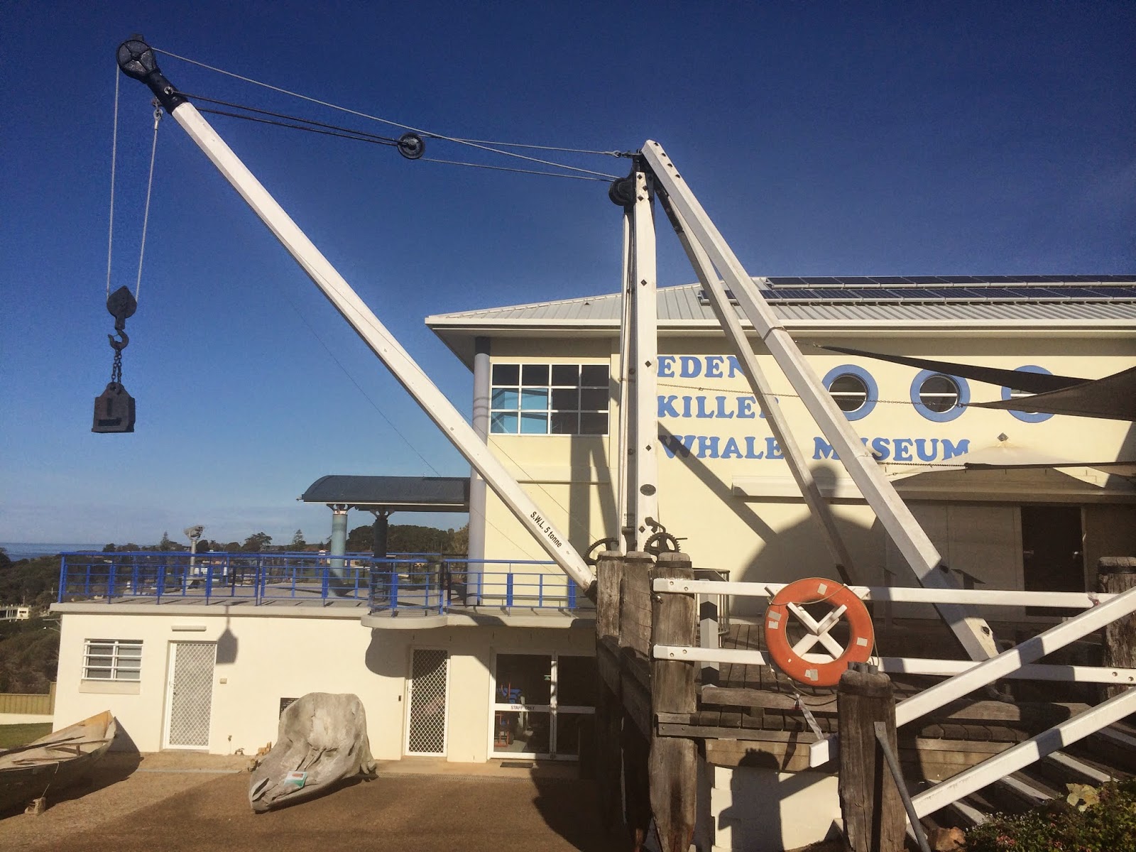
timber, whale produce, livestock, gold, farm produce and seafoods over time. Vic and I headed to the Eden Killer Whale Museum,
which we’d been told, is a must-do when you visit Eden. The displays are fantastic and with our
concession (to my old age!) the $17 entry, for us both, was excellent value.
As it’s name suggests, this museum deals
with Eden’s extensive whaling history, which is said to be thousands of years
old. It’s believed that the original
landowners, the Thawa Aboriginal tribe, had a working relationship with the
whales that came to the area. This
relationship continued when European settlement was established and the first whaling
station was built in 1828. Through the
displays here you learn about “Old Tom”, a Killer Whale and his pack that
worked with the local fishermen for decades during the late 1800’s and early
1900’s.
 |
| Original whaleboat |
 |
| Size of Ol' Tom's fin |
These Killer Whales that returned here each
year, were identified by their markings and named. Tom, Hooky, Humpy, Stranger and others would
herd the smaller Baleen Whales into Twofold Bay and then alert the whalers by
thrashing the water with their tails (flop tailing). The chase would commence and when the Baleen
Whales were harpooned, the Killer Whales would speed up the smaller whale’s death
by rolling over it’s blow hole to prevent it from breathing while others would
swim below it to stop it from diving.
‘Old Tom’ would sometimes get impatient at the speed the whalemen rowed
and would take the rope into his mouth and tow the boat to the whales. You can see, on his jaws, where his teeth
became grooved, by doing this over time. When the harpooned whale succumbed, the
killer whales would take the tongue and lips as payment and leave the carcass
for the whalemen to bring ashore. This
came to be known locally, as ‘The Law of the Tongue’. There has never been any such relationship
between wild animals and humans documented anywhere else in the world. The last whale was taken in Twofold Bay in
1928 and Old Tom’s body was found floating in the Bay On the 17th
September 1930. His skeleton was
preserved and kept as the first item to be displayed in the museum.
 |
| Old Tom's skeleton |
 |
| Ol' Tom's damaged teeth |
You can read about a lot of whaling
stories, such as how a large hole, about 5’ x 3’, would be cut into the rotting
whale carcass and rheumatic sufferers would climb into the hole and stand in
the whale for up to 1½ hours to ease their condition, or of the real life
Jonah. In February 1891, a huge
harpooned sperm whale dived 800’ before rising under the boat and smashing it
to pieces with the loss of two whalers.
At sunset, the whale died and was towed ashore for immediate processing,
and as the stomach was removed, it was squirming, so the men cut it open and
inside, unconscious, was one of the missing men, alive. After spending 15 hours inside the whale,
James Bartley’s skin was permanently bleached white, he lost his hair and was
nearly blind. He was delirious for 2
weeks and couldn’t speak for a month, but lived another 18 years before dying
at 39. If you visit Eden, be sure to go
to the museum, it’s a great place to spend a few hours.
There is a bar-b-q held at the van park
here every Friday night so we had an enjoyable happy hour at the outdoor area
and met quite a few of the other caravanners, and it was interesting to learn
that many of them are travelling with travel auction vouchers also. Some said they have planned their whole trip
based on the vouchers they had won. The
bar-b-q was a lot of fun and we met some really nice people while enjoying a
few cold drinks. We were glad we changed
sites during the day because we got to see the Broncos down the Titans, 27-14.
The next day Vic and I packed a picnic
lunch and headed to the Eden monthly markets for a look around, but this was a
non-event, so we drove north to Merimbula and checked out the beaches and headlands.
 |
|
Merimbula |
This is the largest town on the Sapphire
Coast (which stretches from north of Bermagui to the Victoria/NSW border) with
a regional airport and much larger shopping hub. From here it’s a 7 hour drive to Melbourne, 6
to Sydney and 3 to Canberra. This is
where many people from Eden come to do their groceries etc and commute to for work. We found a quiet park overlooking Merimbula
Lake and made use of the free bar-b-q to cook our brunch. I was surprised that we had the place to
ourselves considering it was such a nice day.
 On the way back to Eden we stopped off at
the little town of Pambula, set in the valley of the Pambula River. The name comes from the Yuin Aboriginal word
for ‘two waters’, and sits by a lake and near the mouth of the river where it
empties into the ocean. It’s a quaint
little historic village and has lots of boutique stores and cafes.
On the way back to Eden we stopped off at
the little town of Pambula, set in the valley of the Pambula River. The name comes from the Yuin Aboriginal word
for ‘two waters’, and sits by a lake and near the mouth of the river where it
empties into the ocean. It’s a quaint
little historic village and has lots of boutique stores and cafes.
We had a couple of wet days during the
week, which gave us the opportunity to veg out and do some chores around the
van. The 19th May saw the
passing of my lifelong hero, Jack Brabham, at the age of 88. As a young bloke I idolized Jack, and because
of my interest in motor racing, my brother Bob used to take me to the Lakeside
Raceway. We would watch legends like
Norm Beechey, Bob Jane and Alan Moffatt race there and some great memories were
created… but I never got to see Jack Brabham race. RIP Jack!
 |
| Quarantine Bay |
 Vic and I packed another picnic one morning
and headed south from Eden, following the ‘Killer Whale Trail’. First we pulled into Quarantine Bay, a really
pretty spot where there is a triple lane boat ramp, fish cleaning tables and floating
wharves. It was so named because of its’
intended use after 1850. In 1855, the “Caesar”,
suffering an outbreak of small pox, took refuge in this bay, which was isolated
from Eden at the time.
Vic and I packed another picnic one morning
and headed south from Eden, following the ‘Killer Whale Trail’. First we pulled into Quarantine Bay, a really
pretty spot where there is a triple lane boat ramp, fish cleaning tables and floating
wharves. It was so named because of its’
intended use after 1850. In 1855, the “Caesar”,
suffering an outbreak of small pox, took refuge in this bay, which was isolated
from Eden at the time.
As many as 66
people had died during the voyage from Hamburg, Germany, and were buried here in
a communal grave.
 We stayed here for
ages watching a resident Grey Fur Seal being fed by a fisherman as he cleaned
his catch. Two huge stingrays cruised
around as well, along with heaps of pelicans and sea gulls.
We stayed here for
ages watching a resident Grey Fur Seal being fed by a fisherman as he cleaned
his catch. Two huge stingrays cruised
around as well, along with heaps of pelicans and sea gulls.
 |
| Fur seal and large stingray at Quarantine Bay |
We left here and a little further on,
turned into Boydtown, a place with an interesting history. Ben Boyd was a Scottish born entrepreneur who
left London in 1840, after floating one million pounds on the London Stock
Exchange, and sailed to Twofold Bay with a dream of setting up a vast commercial
empire. He was keen to establish a port
here, which would enable him to ship wool from his properties on the Monaro and
the Riverina and whale products from his station, while handling goods coming
in and out of the area. Two years after
setting sail, (by 1842) he was rated as one of the largest landholders and
graziers in the colony. After a global
recession, the shipwreck of some of his fleet, and, many bad decisions, his
empire crumbled. In 1849, discredited
and almost penniless, he abandoned his dream and sailed to the goldfields of
California. He was murdered in the Solomon Islands, aged 48.
As part of Boyd’s empire, Boydtown was commenced in 1843. Local brick, timber
and stone was used in the building of a church, hotel, stores and houses.
 Some of the buildings remain, but the
standout is the Seahorse Inn, a magnificent building with a mix of Elizabethan,
Georgian and Tudor styling, which began construction in 1843 but was never completed because of the collapse of Boyd’s empire.
Some of the buildings remain, but the
standout is the Seahorse Inn, a magnificent building with a mix of Elizabethan,
Georgian and Tudor styling, which began construction in 1843 but was never completed because of the collapse of Boyd’s empire.
It has been restored and extended, beginning
in 1936, and renovations as a boutique hotel were finally finished in
2006. “Seahorse” was the name of the
paddle steamer Boyd purchased in 1840 for his trip to Australia. Only the brickwork remains of the church
after a bushfire, in 1926, burnt down the shingle roof and most of the
woodwork.
 |
| Boydstown Church |
Commenced in 1844, it was
never consecrated. The building is
unstable and there is no access to it today.
From here, we returned to the Princes
Highway and 18klms south of Eden, we turned onto Edrom Road and headed towards
the Ben Boyd National Park. We visited
the Davidson Whaling Station, at Kiah Inlet, that was set up in 1866 when
Alexander Davidson and his sons came here following the Kiandra gold rush.
 |
| Loch Garra |
The homestead, ‘Loch Garra’, was built in
1896 using timber salvaged from the wreck of the “Lawrence Frost” and family
descendants still use the home. The
whaling station operated here until the local whaling industry died in
1929. The Davidson’s had the
longest
serving shore based whaling station in Australia and Vic and I spent some time
looking around the remains of the try-works on the shore of the inlet. This is where whales were processed, turning
their blubber into oil. Apparently it
was a pretty dangerous place while the try-works operated because the waters
were thick with large sharks.
 |
| Site of the Davidson's Whaling Station |
Next place to see was Edrom Lodge. This is a beautiful home built in 1913 for
local businessman, J.R. Logan who was responsible for the preservation of ‘Old
Tom’s’ skeleton and became the driving force behind the establishment of the
Eden Killer Whale Museum.
 |
| Edrom Lodge |
The lodge sits
on the site once occupied by ‘Merton’, a cottage built for Oswald Brierly, who
was Ben Boyd’s overseer. It’s only
possible to see the homestead by walking out onto the Navy Wharf, which curves
around in front of the home. If the Navy
is in port, no access to the wharf is allowed so we were lucky they weren’t
home when we visited.
 |
| Boyd's Tower on Red Point (South Head) |
The final place on the trail was Boyd’s
Tower. This structure really shows the
extent of Boyd’s dream and stands among a forest of gnarled tea trees, on Red
Point (South Head), the southern point side of Twofold Bay. Building commenced in 1846, with an
extravagant use of Pyrmont sandstone, shipped from Sydney, and Sydney blue gum
hardwood. It was originally designed as
a lighthouse but Boyd was never given permission by the NSW Government to use
it as such.
 |
| View from Boyd's Tower |
 At 23 metres, it is quite imposing
and was used as a whale watching tower by the Boyd whalers and the Davidson Family
after they took over the operations.
Whale watchers would communicate with the shore station, when they
spotted a target, using mounted riders, gunshot or smoke signals.
The tower was owned by the Davidson Family
until 1960, when it was handed to the Government to form part of the Ben Boyd
National Park.
At 23 metres, it is quite imposing
and was used as a whale watching tower by the Boyd whalers and the Davidson Family
after they took over the operations.
Whale watchers would communicate with the shore station, when they
spotted a target, using mounted riders, gunshot or smoke signals.
The tower was owned by the Davidson Family
until 1960, when it was handed to the Government to form part of the Ben Boyd
National Park.
 |
| View from Ben Boyd National Park |
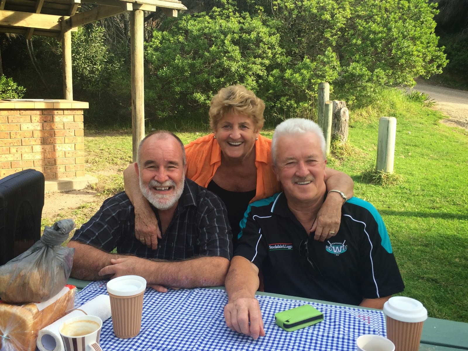
Vic and I had a couple of quiet days around
the van before we took another drive up to Merimbula to grab some
groceries. We met up with Lyn and Neil,
a retired couple from Wonthaggi (in Victoria), who camped beside us and we had met
at one of the many happy hours.
 |
| Wharf Restaurant at Merimbula |
The four
of us went over to the Wharf Restaurant, overlooking the Merimbula River mouth,
and while we had a great Devonshire tea, a pod of dolphins were feeding just in
front of us.
 |
| Lyn & Neil - two lovely people who we met at Eden |
Since leaving Helensvale on the 27th
April, we seem to have been on the move constantly, even after these ten days
in Eden. With Vic seeming to be so well
recovered, it’s easy to forget the severity of the event that had her in
surgery a few months back, though she does get very tired. She has organized a housesit for us in
Victoria, which will allow us to take some time to sit back and take it easy
for a month, so we are looking forward to heading out of Eden and continuing
south.
Until next time… Happy travels!


 This is the largest town on the Sapphire
Coast (which stretches from north of Bermagui to the Victoria/NSW border) with
a regional airport and much larger shopping hub. From here it’s a 7 hour drive to Melbourne, 6
to Sydney and 3 to Canberra. This is
where many people from Eden come to do their groceries etc and commute to for work. We found a quiet park overlooking Merimbula
Lake and made use of the free bar-b-q to cook our brunch. I was surprised that we had the place to
ourselves considering it was such a nice day.
This is the largest town on the Sapphire
Coast (which stretches from north of Bermagui to the Victoria/NSW border) with
a regional airport and much larger shopping hub. From here it’s a 7 hour drive to Melbourne, 6
to Sydney and 3 to Canberra. This is
where many people from Eden come to do their groceries etc and commute to for work. We found a quiet park overlooking Merimbula
Lake and made use of the free bar-b-q to cook our brunch. I was surprised that we had the place to
ourselves considering it was such a nice day.